

During times of emergency, The Foggiest Idea consolidates the reports of various news outlets to provide accurate, timely, and useful information to help reduce the spread of misinformation that jeopardizes timely response.
Sources of consolidated updates include the offices of local and state elected officials, agencies such as the National Weather Service and Centers for Disease Control, and publications such as the New York Times, Washington Post, Wall Street Journal, and Newsday.
Given the expected impacts from Hurricane Henri, the first hurricane system to make landfall on Long Island since 1985’s Hurricane Gloria, TFI is keeping a running thread of the latest developments and policy analysis. Please be mindful of the time and date, highlighted in bold, of each update.
By Richard Murdocco
HENRI SWEEPS PAST LONG ISLAND, LOSES STEAM AFTER HITTING RHODE ISLAND (UPDATE AS OF 1:15 PM, SUNDAY, AUGUST 22nd, 2021)
After being forecast as a pending storm with weighty historic significance for Long Island, Tropical Storm Henri amounted to little more than a breezy rain event for a majority of the New York metro region. Even Long Island’s East End, slated to be the epicenter of the storm’s impact, was spared the worst.
Instead of smacking directly into Suffolk County as forecasted, the storm shifted further eastward, passed over Block Island, and made landfall at 12:15 PM Sunday near Westerly, Rhode Island.
Compared to the steady rains Henri brought to Long Island, the picture on Rhode Island’s coast was less humdrum – nearly 75,000 residents were without power by Sunday afternoon as the cyclone hit.
For Suffolk County, Tropical Storm Henri will be a soaking event, with forecasts calling for 4″ of rainfall for most areas – with some local spots getting as much as 6″.
Once Henri took to it’s final track into southeastern New England, PSEG Long Island exhaled a sigh of relief after the utility brought in over 3,700 workers to brace for the storm. PSEG had warned ratepayers that power outages could last upwards of 14 days as recently as Saturday.
Due to their botched response to Tropical Storm Isaias last year that left 440,000 residents without power and as the recipient of a new contract with LIPA, a deal that has since come under scrutiny with elected officials, the utility had much to prove about their storm readiness plans.
For now, the utility was granted the gift of time by Mother Nature – That is, until the next storm sets its sights on Long Island.
This is the last update related to Tropical Storm Henri. Thank you for following The Foggiest Idea.
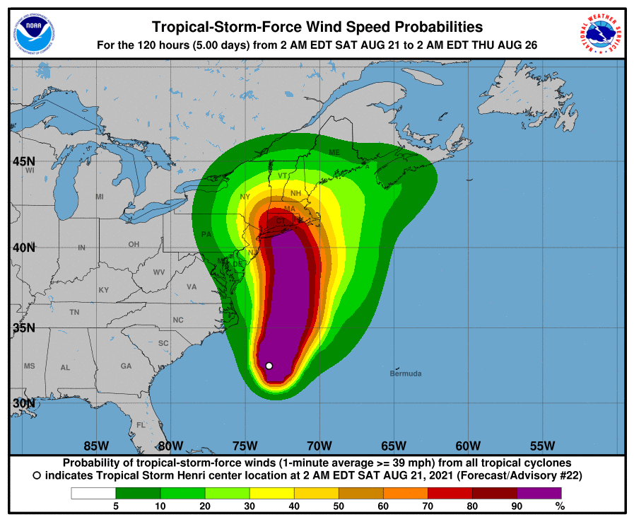
HENRI DOWNGRADED TO TROPICAL STORM – LONG ISLAND NARROWLY AVOIDS DIRECT HIT (UPDATE AS OF 8:30 AM, SUNDAY, AUGUST 22nd, 2021)
Long Island narrowly avoided a direct strike from a downgraded Tropical Storm Henri on Sunday morning, as latest tracks now show the system making landfall along the coast of Rhode Island.
With the storm weakening, the hurricane warnings that were issued for Long Island, the southern coast of New England, and Block Island have been changed to a tropical storm
warnings.
The National Weather Service said early Sunday that the colder waters north of the Gulf Stream weakened Henri, which now boasts maximum sustained winds of 70 mph with higher gusts.
Originally, Henri was slated to be the first hurricane to directly hit Long Island since Hurricane Gloria, which struck the region as a Category 1 storm in 1985.
Forecasters urged that the storm’s presence will still be felt across eastern Suffolk County thanks to the heavy rains, damaging tropical storm-force winds, and the storm surges that Henri is expected to bring. Nassau County and points west are likely to face reduced impacts. Rainfall amounts of 3 to 6 inches are expected, with isolated areas experiencing nearly 10 inches.
Coastal areas still face dangerous storm surges ranging 3 to 5 feet, with the worst conditions slated for areas located along the Long Island Sound. Henri sits 40 miles southeast of Montauk point and is traveling northwest at 16 mph.
HURRICANE HENRI SHIFTS EAST, BRUNT OF STORM EXPECTED EARLY SUNDAY (UPDATE AS OF 9:00 PM, SATURDAY, AUGUST 21st, 2021)
While Hurricane Henri’s predicted track has shifted slightly eastward, it doesn’t much matter – experts say that the majority of Suffolk County will face hurricane conditions early Sunday morning.
Craig Allen, chief meteorologist for WCBS 880, stated Saturday evening that Long Islanders shouldn’t focus on Henri’s exact track because tropical conditions radiate from the storm up to 110 miles out. Instead, Allen says that residents should be wary of Henri’s prolonged rains, storm surges, and likelihood of extended power outages, which PSEG Long Island warned could last upwards of 14-days in hardest hit areas.
As of writing, Hurricane Henri was churning 235 miles south of Montauk, and moving at a steady 18 mph north towards the region. According to the National Oceanic and Atmospheric Administration (NOAA), Henri is expected to further strengthen through this evening, followed by some weakening right before landfall is made.
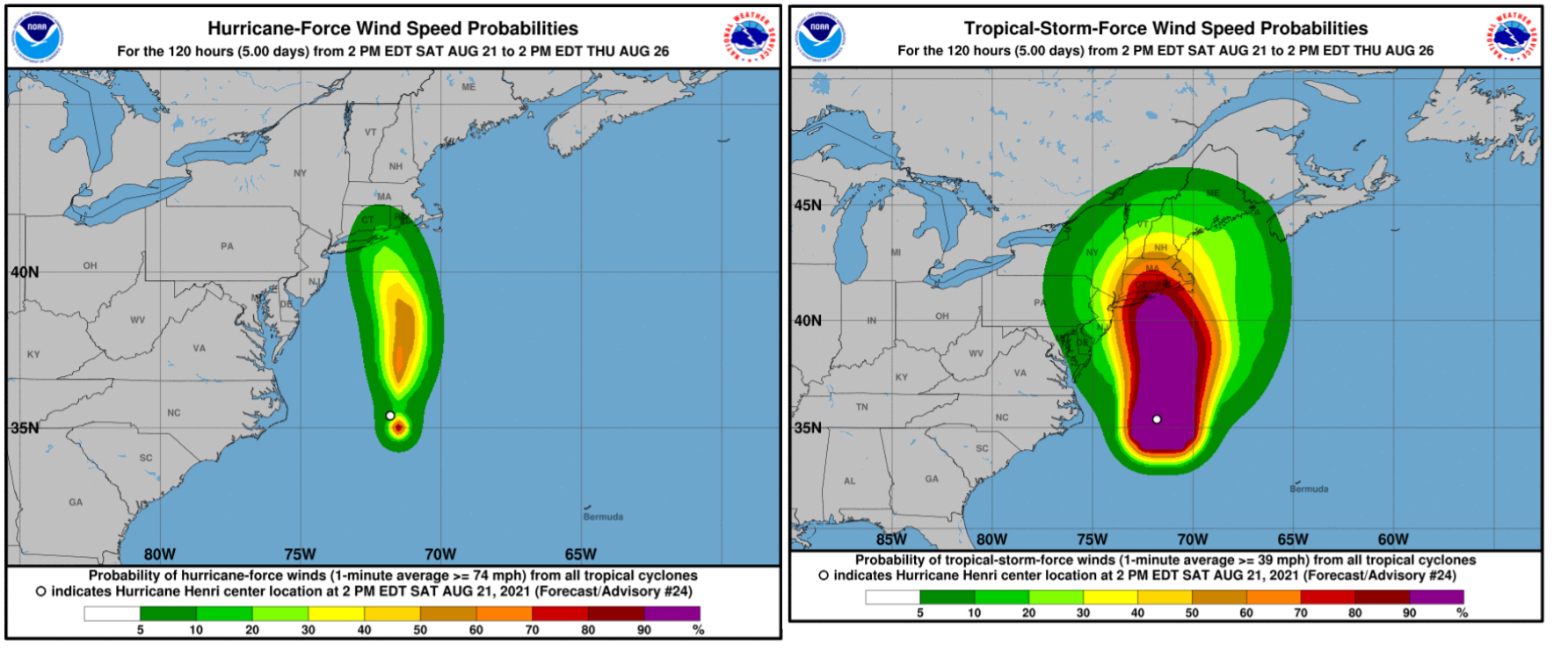
Pictured: The latest expected forecasts for hurricane and tropical storm-force winds. Please disregard all previous images showing Henri’s track. (Photo Source: NWS NY)
Regardless, the agency notes that Henri will be at or near hurricane strength when it eventually strikes Long Island and southern New England. Henri’s hurricane-force winds radiate out roughly 45 miles from the storm’s eye, while tropical storm-force winds extend up to 150 miles. Forecasters expect the peak of the storm to hit roughly late Sunday morning through the afternoon, and warn that the East End and coastal southeast Connecticut face the highest storm surge threats.
“It’s all about when it gets pulled left or westward by the approaching system from the system to Henri’s west and where the block positions itself over the Atlantic,” Allen wrote on his popular Facebook page. “That will determine when the left turn begins and how far west Henri will go before moving up and getting caught in the westerlies, to get ejected across New England and out to sea.”
The National Weather Service warned that all declared hurricane, tropical storm, and storm surge alerts remain in effect for the majority of the region, and that the storm’s wind threat has remained steady from the agency’s previous assessments.
Getting around is likely to difficult in the coming hours since the Port Authority is anticipating canceling flights at New York’s airports, and Governor Cuomo noted that the MTA will likely suspend all Long Island Rail Road service east of Ronkonkoma early Sunday.
No further updates are expected until Sunday. Stay safe! – RJM
THE CALM BEFORE THE STORM (UPDATE AS OF 4:30 PM, SATURDAY, AUGUST 21st, 2021)
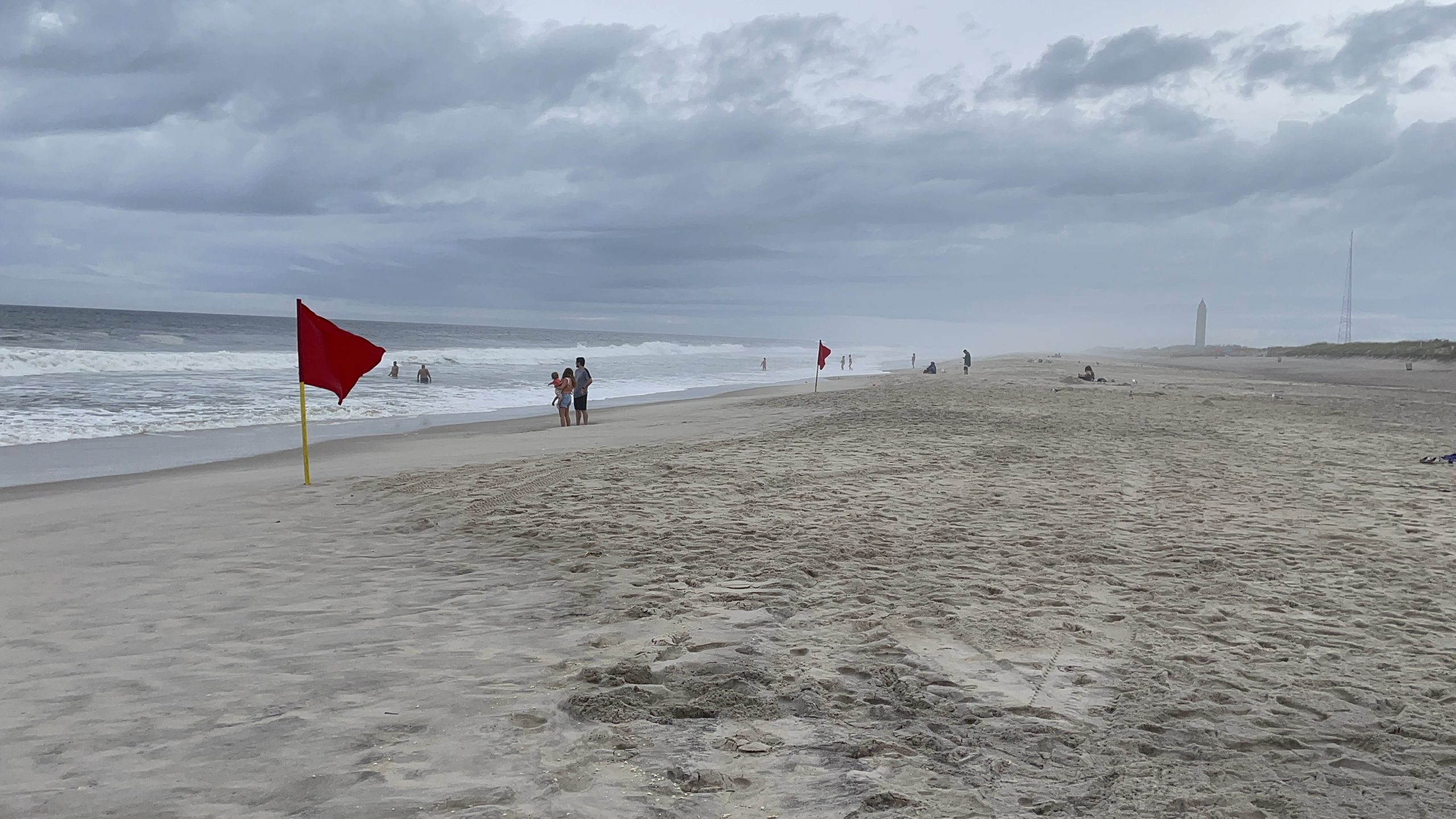
Pictured: Muted crowds gather at Robert Moses State Park to look at the sizable waves from approaching Hurricane Henri on Saturday afternoon. Henri is slated to be the first hurricane since 1985’s Gloria to make landfall on Long Island. (Photo Credit: Richard Murdocco/The Foggiest Idea)
HURRICANE HENRI ON TRACK TO SLAM EASTERN LONG ISLAND (UPDATE AS OF 3:00 PM, SATURDAY, AUGUST 21st, 2021)
Latest forecasts show that Henri, officially upgraded to a Category 1 storm by forecasters earlier this morning, has shifted eastward, putting the system on track to hit eastern Long Island and southeastern Connecticut by early Sunday afternoon.
Forecasters say that eastern Suffolk County will experience the brunt of the storm, complete with 75 mph sustained winds, with gusts topping out around 90 to 100 mph. Points further west, including Nassau County and New York City, can expect tropical storm force winds, with 50-60 mph sustained winds and gusts up to 80 mph.
Henri is expected to bring driving drenching rains to much of the region, with 3″ to 7″ of rainfall likely within the hardest hit areas. In addition, dangerous storm surge conditions are likely to impact coastal areas across eastern Suffolk County, with 3 to 4 feet of inundation expected during the upcoming high tide cycles.
In an emailed statement to ratepayers, PSEG Long Island warned that power outages in Henri’s wake could last up to 14 days if the storm tracks further west.
“I hope people take this very seriously,” outgoing New York State Governor Andrew Cuomo said to a reporters during an afternoon briefing. Cuomo later announced he was declaring a state of emergency for impacted areas. Cuomo also said that he is deploying National Guard troops, State Police and other emergency assets in anticipation of the storm.
Locally, officials have urged residents and visitors on Fire Island to evacuate voluntarily, with ferry service to and from the island ending later Saturday evening with a 10:40 PM ferry departure.
“It is important for residents and visitors to understand that if they do not leave the island today, they will be stuck on the Island and we do not know what kind of conditions they will be facing. But, they could be difficult, they could be dangerous,” Suffolk County Steve Bellone said during a press conference urging those on the island to leave.
LONG ISLAND BRACES FOR HURRICANE HENRI (UPDATE AS OF 8:00 AM, SATURDAY, AUGUST 21st, 2021)
Suffolk County is currently under a Hurricane Warning for the first time in a decade, as Tropical Storm Henri (pronounced Ohn-ree) is expected to make landfall as a Category 1 hurricane somewhere on Long Island’s south shore early Sunday afternoon. Further west, both Nassau County and New York City are under a Tropical Storm Warning.
Forecasters from the National Weather Service expect Henri to bring life-threatening storm surge, heavy rain capable of producing flash flooding, hurricane force winds from 75 mph and above along Long Island and across southern Connecticut. Tropical force winds can arrive as early as Saturday night, meteorologists said.
(Photo Source: National Weather Service)
Henri will be the first hurricane to directly strike Long Island since 1985’s Hurricane Gloria, and policymakers, residents, and PSEG Long Island are bracing for the worst.
The blaring warnings from the National Weather Service heralding Henri’s arrival shattered the relative peace of one of the last summer Fridays of the season, alerting Long Islanders about the risk of life-threatening storm surges and damaging winds Henri is likely to bring.
Initially, forecasters called for Henri to strike further east around Montauk Point, but the outlook for Nassau and Suffolk Counties significantly worsened by Friday afternoon. “There has been a dramatic change in the expected path of that storm,” meteorologist Bill Korbel told Newsday yesterday, noting that the path had shifted 175 miles to the west.
PSEG Long Island warned that Henri’s path can cause prolonged power outages that could last seven to 10 days, and urged residents to prepare accordingly.
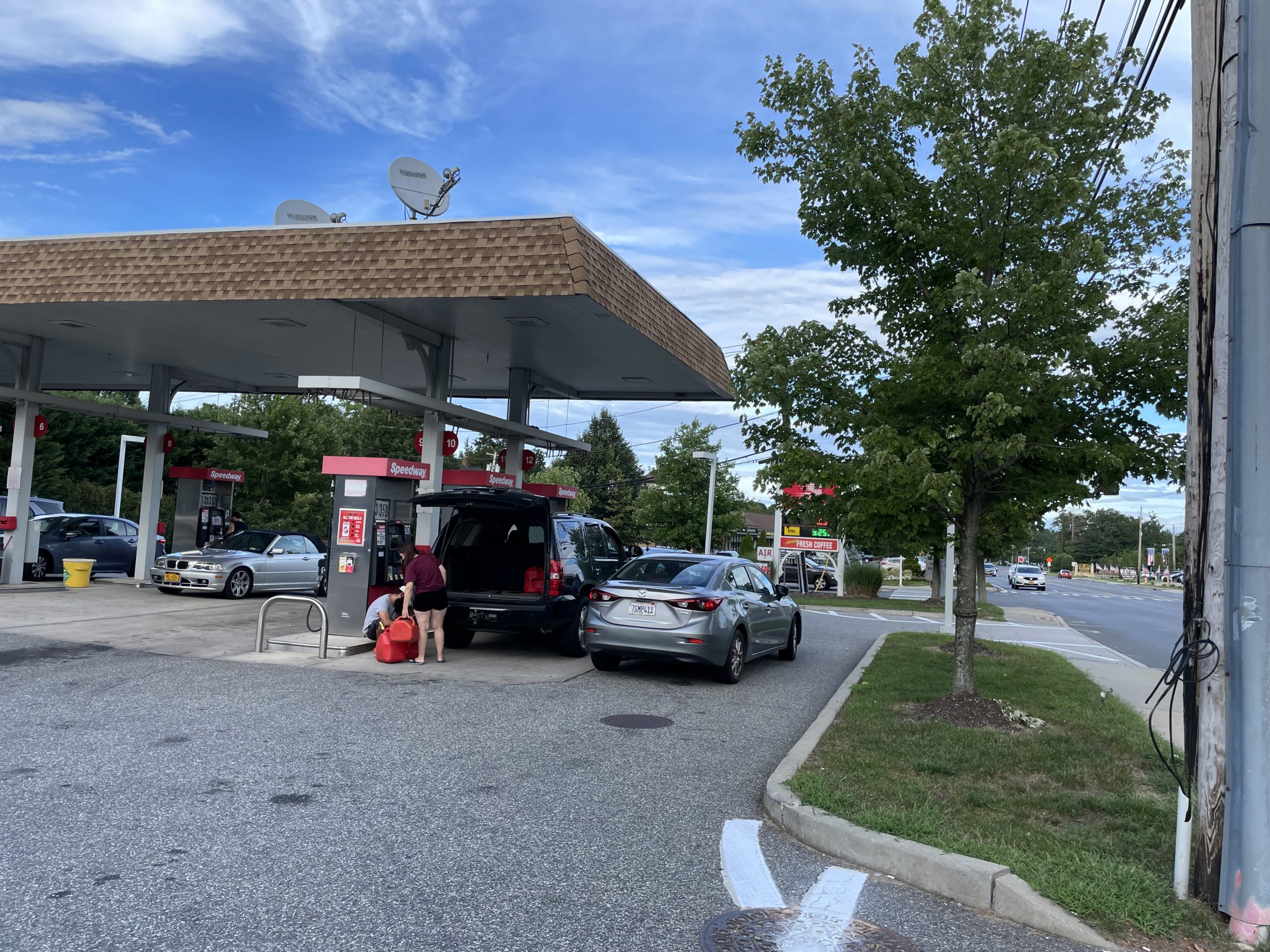
Pictured: Residents in Commack fill up their cars and gas cans in anticipation of Henri’s arrival. On Friday, PSEG LI warned the storm is likely to bring prolonged power outages. (Photo Credit: Richard Murdocco/The Foggiest Idea)
“We continue to monitor the track of Tropical Storm Henri,” Michael Sullivan, senior director of Transmission and Distribution at PSEG Long Island, said in an issued statement. “As the storm makes its way up the coast, employees are preparing for the possibility of high winds that can cause flying debris, and bring down trees and power lines.” PSEG has brought in 1,200 additional workers in anticipation of Henri, and plans to bring in crews from National Grid as needed.
The utility, whose contract was recently renewed from LIPA in a move that surprised both state elected officials and residents after their failure to respond in the wake of Tropical Storm Isaias one year ago, is already coming under fire.
“Potential seven to 10-day power outages are unacceptable,” Nassau County Executive Laura Curran said in arapid-fire statement that was issued shortly after PSEG’s warnings. “While we are all hoping for the best outcome this weekend, PSEG must call in additional crews who are prepared to respond to our residents’ outages.”
With Isaias, 535,000 customers lost power, and PSEG’s failed storm response triggered LIPA outright suing PSEG for breach of contract. In June, LIPA and PSEG had reached a tentative agreement on a new contract, but the improvements mandated are not slated to take effect until the new year, serving as little help as Henri makes it’s way north.
As of 5:30 AM Saturday, the strengthening storm is about 530 miles south of New York City, and is moving towards the northeast at 12 mph.
Please check the National Weather Service and local agencies for the latest weather-related updates.


